Juichiro ASHI (Assoc. Professor)
|
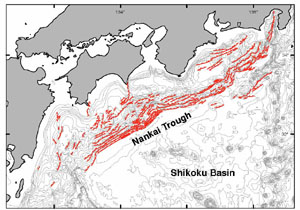
1) Active Fault |
|
|
 |
|
|
|
|
|
|
|
|
|
|
2) Methane Hydrate BSR |
|
|
|
|
|
|
|
|
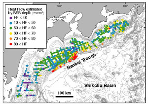
Methane Hydrate is significant for considering hydrocarbon circulation, global warming and slope instability. Moreover, BSRs (Bottom simulating reflectors) on seismic profiles, regarded as boundaries between methane hydrate bearing sequences above and free gas zone below, can be used for estimation of geothermal gradient and gas migration process. We are mapping BSR distributions in the Nankai accretionary prism and the forearc basins, and estimating heat flow and methane accumulation processes (Ashi and Taira, 1993; Ashi et al., 2001).
Fig. 2 Map showing distribution of methane hydrate BSR and heat flow in the Nankai Trough
|
|
|
|
|
|
|
|
3) Mud Volcano |
|
|
|
|
|
|
|
|
|
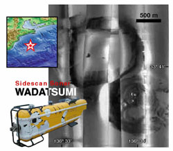
Mud volcanoes are surface expressions of mud diapirs that transport unconsolidated muddy materials from the deep. Study on mud volcano provides us with geological, geochemical and microbiological information at the deeper part that we never penetrate by deep-sea drilling. Our survey using side-scan sonar, piston core and submersible, has been conducted on the Kumano Trough. We revealed surface structures, materials and cessation age of the mud volcanoes (Sawada et al., 2001).
Fig. 3 Deep-tow side scan sonar system "WADATSUMI" and the mosaic image of mud volcanoes in the Kumano Trough
|
|
|
|
|
|
|
|
4) Cold Seep and Tectonics
|
|
|
|
|
|
|
|
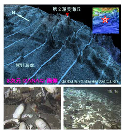
Cold seep is strongly controlled by tectonics in subduction zones. Subbottom structures associated with conduits can be estimated from seep distribution and fluid chemistry. In the Nankai Trough, we are mapping chemosynthetic biological communities indicating methane seep sites by submersibles and deep-tow video cameras. Previous study shows that most seep sites are located at active faults (Active Submarine Fault Research Group, 1999; Ashi et al., 2002) and mud volcanoes.
Fig. 4 3D mosaic image of IZANAGI side-scan sonar at the Daini Atsumi Knoll and clam colony observed by JAMSTEC "Shinkai 2000"
|
|
 |
|
|
|
|
|
|
|
5) Gamma Ray Monitoring |
|
|
|
|
|
|
 |
|
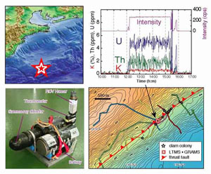
Seafloor gamma ray has been routinely measured by JAMSTEC submersibles and ROV. In order to conduct long-term monitoring of gamma ray without seafloor disturbance during landing and taking-off, we developed a stand-alone tool, named GRAMS (Gamma Ray Monitoring System). Very high contents of U-series radionuclide were detected along the active faults of the Nankai accretionary prism (Ashi et al., 2003). We are evaluating whether gamma ray is a proxy of rock deformation along a deep part of a fault zoon or not.
Fig. 5 Gamma Ray Monitoring System and high contents of U-series radionuclide recorded at the out-of-sequence thrust off Kumano.
|
|
|
|
|
|
|