KH05-1 Leg3 Summary
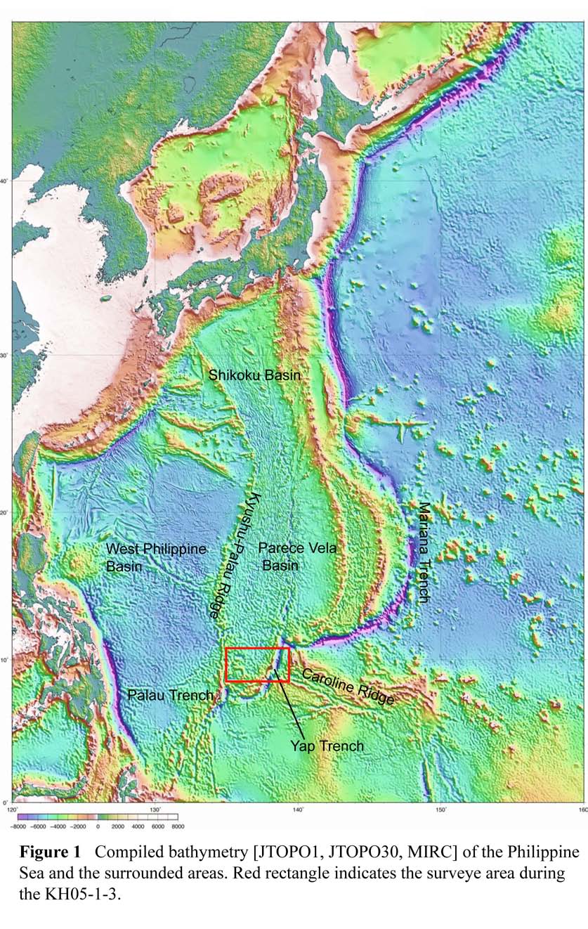
The KH05-1-3 cruise aboard the R/V Hakuho-maru (JAMSTEC) were planned to reveal the evolution history of the southern Parece Vela Basin and the structure of the Yap trench-arc system. The ship left Guam on June 15, 2005 and returned to Guam on June 27, 2005. We successfully conducted the extensive geophysical mapping in the southern tip of the basin, long across-trench multi-channel reflection survey and two dredge hauls.
The primary objective of KH05-1 Leg3 is to reveal the structure of the southern tip of the PVB, and then to confirm the evolution model proposed by [Fujiwara et al., 2000; Ohara et al., 2002]. To tackle this problem, we will conduct the geophysical mapping of the backarc side of the Yap trench-arc, obtain the reflection and gravity profiles across whole trench-arc-basin system, and some dredge hauls. The question to be solved are:
- Evolution process of the southern tip of the PVB
- Are there N-S and/or NW-SE abyssal hills?
- Was the area formed as a western wing of the basin?
- If so, how was the fate of the eastern wing of the basin? Eroded?
- How did the junction between the PVR and the Yap Trench develop?
- The relationship of the basin evolution and the collision of the Caroline Ridge
- When and how did the Caroline Ridge collide with the Yap Trench?
- Did the Yap Island obduct the trench?
- Is the Caroline Ridge subducting now?
- The lithospheric composition of the southern tip of the basin
The highlights of our results are summarized as follows:
- The southern tip of the Parece Vela Basin has been mapped using state-of-the-art instruments for the first time. The southward propagator tip of the Parece Vela Basin spreading center was discovered. The seismic profile from the Caroline Ridge to the basin was acquired.
- The western part of the survey area is characterized by “curved” deeps and robust magmatism. The kinematics of the enigmatic “curved” structure remains unsolved but it may be related to the rotational deformation associated with continuous rift propagation and fracture zones. Dredging on the foot of one of the curved deeps recovered some rock samples.
KH05-1 Leg5 Summary
The KH05-1-5 cruise aboard the R/V Hakuho-maru (JAMSTEC) were planned to integrate the following three proposals in the Philippine Sea area.
- (1)
- Geological cross section of island-arc system with back-arc basin (PI: T. Ishii)
- (2)
- Tectonics and lithospheric composition of the southern Parece Vela Basin (PIs: K.
Okino and Y. Ohara)
- (3)
- Revealing tectonic history of oceanic island arc based on volcanic history of
monogenetic volcanoes (PI: O. Ishizuka)
*Second proposal was partly achieved in KH05-1-3.
Based on these proposals, we selected four target areas for focused survey: Area A: Southern Mariana Trench Inner-wall Area B: Southern Parece Vela Rift Area C: Southern Ogasawara Ridge Area D: West of Soufugan Tectonic Line The ship left Guam on July 17, 2005 and returned to Tokyo on July 31, 2005. We successfully conducted the extensive geophysical mapping and total 26 dredging were conducted.
The highlights of Area B survey are summarized as follows:
- In the southwest of the intersection between PVR and the Yap Trench, four segments were mapped. The close up view of the area is shown in Fig. 12. The abyssal hills in the easternmost segment are trending 110~115°, which are approximately perpendicular to the 025° fracture zones. In western three segments, the dominant direction of abyssal hills is 150°, which is oblique to the trend of fracture zones. These abyssal hills may be due to the oblique spreading in the past. The general trend of the fracture zone in the area is 025°, however some small features trending 060° (=perpendicular to “oblique” abyssal hills) are recognized within the fracture zone valley. It may indicate that the stress field had changed during the evolution of the segment.
- We performed in total 7 dredge hauls (D7 to D13) in the Area B during the KH05-1-Leg 5 cruise. The main results can be summarized as follows:
- (1)
- Dredging on the conjugate southeast-dipping scarp of NYE yielded mantle peridotites including lherzolites, indicating that the southern tip of PVR exposes mantle material with backarc basin affinities.
- (2)
- On the other hand, dredging on the northernmost NYE yielded conglomerates very similar to those reported in Ohara et al. (2002), indicating that the northernmost NYE exposes volcanics with arc-like affinities.
Dredging on a large OCC-like structure (but smaller than Godzilla Mullion), here named “Minilla Mullion”, yielded fault rocks, gabbroic rocks and basalts. Although
being without peridotites, this rock assemblage indicates the Minilla Mullion exposes
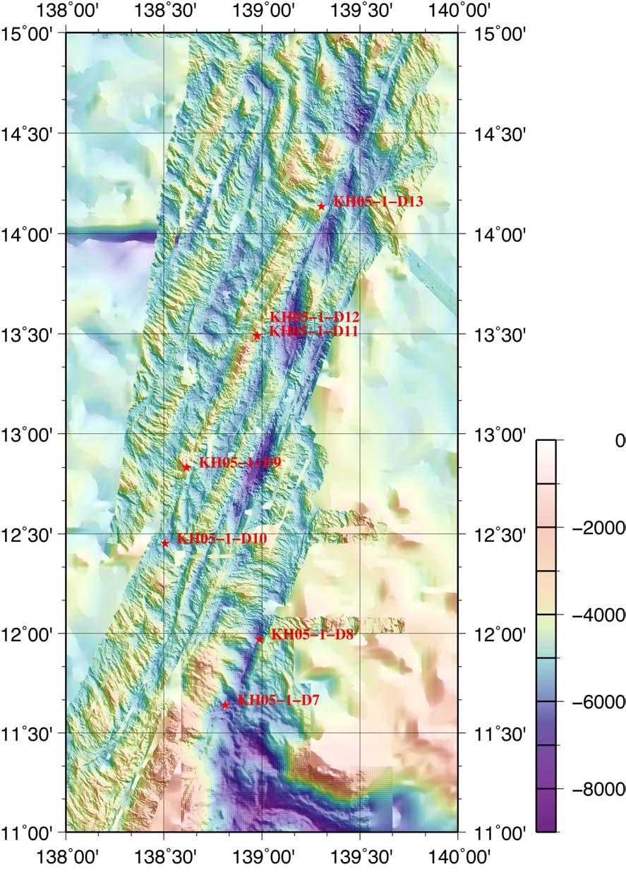
Figure 2 Southern Parece Vela Rift and locations of dredge hauls in KH05-1-5.