- 海嶺軸および周辺における上部マントルの電気伝導度構造探査
海底電位差磁力計による電磁場観測 - 海嶺軸および周辺における地殻の地震波構造探査
エアガン、海底地震計、ストリーマによる人工地震波観測 - 海嶺軸および周辺の海底地形・地球物理探査
海底地形、地磁気、重力観測 - 海嶺軸および断裂帯に沿った岩石採取
岩石のドレッジ
島 伸和・神戸大学内海域環境教育研究センター・准教授
佐藤 利典・千葉大学大学院理学研究科・教授
佐藤 暢・専修大学・経営学部・准教授
佐藤 太一・東京大学海洋研究所・大学院学生
町田 嗣樹・東京大学海洋研究所・教務補佐員
中村 謙太郎・海洋研究開発機構・学振PD
仙田 量子・海洋研究開発機構・ポスドク研究員
根尾 夏紀・新潟大学大学院自然科学研究科・大学院学生
北村 貴幸・千葉大学大学院理学研究科・大学院学生
水野 真理子・千葉大学・理学部・学部学生
竹本 帝人・千葉大学・理学部・学部学生
辻野 良輔・神戸大学・大学院自然科学研究科・大学院学生
水間 恵子・神戸大学・理学部・学部学生
亀尾 桂・東京大学海洋研究所・技術職員
宗 輝・?潟}リン・ワーク・ジャパン・観測技術員
菅野 真人・日本海洋事業?梶E観測技術員
Preliminary report on the Hakuho-maru Cruise KH-07-4 Leg 2, Southwest Indian Ridge
Nobukazu Seama[1]; Kyoko Okino[2]; Toshinori Sato[3]; Hiroshi Sato[4]; Taichi Sato[2]; Shiki Machida[2]; Kentaro Nakamura[5]; Ryoko Senda[5]; Natsuki Neo[6]; Takayuki Kitamura[3]; Mariko Mizuno[3]; Teito Takemoto[3]; Ryosuke Tsujino[1]; Keiko Mizuma[1]; Katsura Kameo[2]; Akira So[7]; Masato Sugano[8]; Yoshifumi Nogi[9]; Hidenori Kumagai[5]; Masanao Shinohara[10]; Kimihiro Mochizuki[10]
[1] Kobe Univ.; [2] ORI, Univ. of Tokyo; [3] Chiba Univ.; [4] Senshu Univ.; [5] IFREE, JAMSTEC; [6] Niigata Univ.; [7] MWJ; [8] NME; [9] NIPR; [10] ERI, Univ. of Tokyo
The mid-ocean ridge process depends on a balance between spreading rate and melt supply, and the melt supply should reflect the physical and chemical character of mantle beneath the ridge. At 34-40oE on the Southwest Indian Ridge, the spreading rate (ultraslow, ~15mm/yr) is the same along this long portion of the ridge. However, the eastern part of the area appears to have anomalously large melt supply maybe due to the proximity to the Marion hotspot, while this effect does not seem to reach the western segments where the ridge axis is offset by a series of fracture zones. In January 2008 on board R/V Hakuho-maru Cruise KH-07-4 Leg 2, we conducted a surface geophysical survey, marine magnetotelluric transect for imaging upper mantle structure, seismic survey for imaging crust structure, and rock dredge sampling to better understand the contribution of mantle geochemistry to the structure and spreading style of mid-ocean ridges. The surface geophysical survey was focused on ridge segments at 35-39oE, and one third of the segments was covered by 11 survey lines, each with length 60 nautical miles. Seven OBEMs were deployed to carry out a marine MT transect across the Southwest Indian Ridge at 37oE. The MT transect across the spreading center will provide an image of the electrical conductivity structure beneath the spreading system after the recovery of the OBEMs during a subsequent Hakuho-maru cruise in February 2009. The seismic survey also targeted the Southwest Indian Ridge at 37oE to investigate seismic velocity structure. Ten OBSs, a 48-channel hydrophone streamer, and two 20-liter air guns were used, and all the data were successfully obtained. Eight rock dredge hauls were performed along the Southwest Indian Ridge 34-40oE to investigate a variation due to different ridge segments. Rock samples were successfully recovered at 6 sites. All of these data sets and rock samples will provide geophysical and geochemical constraints for understanding diversity in spreading style and dynamics beneath an ultraslow-spreading system interacting with a hotspot.
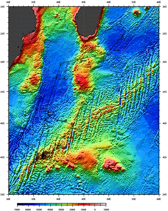
Figure 1a. Ship track of the cruise
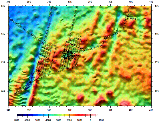
Figure 1b. Ship track of the cruise in the survey area
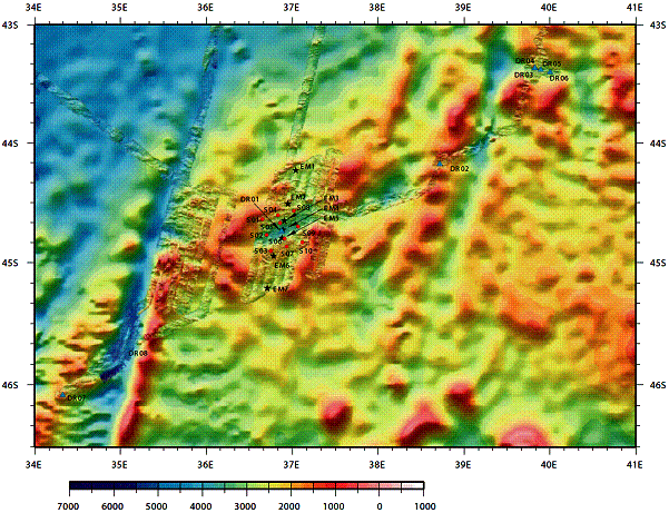
Figure 2. Summary map. OBEM, OBS, and Dredge sites are shown in black stars, red circles, and blue triangles, respectively.