KR07−16かいれい調査航海概要
研究課題名:
海底電位差磁力計による沈み込み・前弧・島弧・背弧系(中部マリアナ海域)の横断探査その3
(海底電位差磁力計の回収)
乗船研究者:
| 氏名 |
所属機関名 |
役職名 |
| 島伸和 |
神戸大学 |
准教授 |
| Alan Chave |
ウッズホール海洋研究所 |
Senior Scientist |
| 辻野良輔 |
神戸大学 |
大学院生 |
| 藤井豊展 |
アバディーン大学 |
ポスドク研究員 |
| Alan J. Jamieson |
アバディーン大学 |
ポスドク技術者 |
| 菅野真人 |
日本海洋事業株式会社 |
観測技術員 |
調査海域:
中部マリアナ海域
(16°00.0′N、 20°00.0′N、141°00.0′E、151°00.0′Eの各経緯度線で囲まれる範囲)
実施期間:
2007年11月26日(月)〜2007年12月2日(日)
調査航海概要:
1. Purpose and Proposal
This project is a Japanese, US, and Australian collaborative research effort. We carried out a marine magnetotelluric transect across the central Mariana subduction system using ocean bottom electro-magnetometers (OBEMs), ocean bottom electrometers (OBEs), and ocean bottom magnetometers (OBMs) to provide a comprehensive image of the electrical conductivity structure of the Mariana island-arc system extending from the Pacific ocean to the West Mariana Ridge (remnant arc) through the Mariana Trough. Subduction zones are fundamental to Earth recycling, controlling the return of crustal materials into the mantle and the partitioning of some fraction back to the surface. The Mariana subduction system is the classic example of an intra-oceanic arc, trench, and back-arc system. Our transect across the central Mariana subduction system, which includes three instances of upwelling of serpentine diapirs, arc volcanism, and back-arc spreading, will address issues of hydration of the mantle wedge resulting from subduction and the nature and distribution of subsequent melting through estimation of the electrical conductivity structure. This will provide a breakthrough for understanding mantle dynamics related to plate subduction.
2 Preliminary Results
2-1. OBEM recovery
We recovered two ocean bottom electric-magnetometers (OBEMs) that had
remained deployed, as the ship was forced to leave the survey area due
to an oncoming typhoon during the previous recovery KR06-12 cruise. One
is Kobe OBEM at site 39 and the other is US OBEM at site 40. Site positions
are given in Figure 1. Upon release, instruments were tracked to the surface
using a variety of acoustic tracking tools. Kobe OBEM utilized the inbuilt
SSBL system on board the R/V Kairei to provide real-time x,y,z positions
in the water column. US OBEM used a combination of slant ranges and the
ship position along with the starting position and measured ascent rates
to calculate the position. By tracking the instruments closely we were
able to accurately predict their surface times and positions and quickly
find them with the ship. The OBEMs were recovered using a platform on the
starboard side of the ship. The instruments were hooked by the crew and
lifted by a chain hoist and crane onto the platform where the instrument
was broken down and moved inboard. This operation was quick and took at
most 30 minutes to complete.

Figure 1.
A Location map of OBEMs, OBMs, and OBEs deployments through the Mariana
subduction system. Open circles show the locations of OBEM recovered during
KR07-16 cruise. Black dots show the locations of OBEM or OBM & OBE
recovered during KR06-12 cruise. The triangles show sites where only the
OBM was recovered. Crosses denote sites where OBEM recovery failed. Red
circles are OBEM sites from previous studies for which data are already
in hand.
Photo 1.

Kobe OBEM |
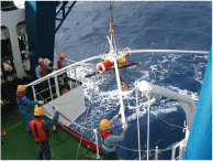
US OBEM |
2-2. Surface Geophysical Survey
We conducted a surface geophysical survey to collect multi-narrow beam bathymetry, magnetic field, and gravity field data. The bathymetry map is shown in Figures 2. Multi-narrow beam bathymetric data were obtained using a SeaBeam 2112, which also provides a backscatter image that will be processed after the cruise. An XBT was done on 29 November at site 39. The DGPS (differential global positioning system) was used to derive the ship’s location. Magnetic field data were collected with two instruments: a shipboard three component magnetometer (STCM: Isezaki, 1986) that can measure the vector geomagnetic field using deck-mounted fluxgate magnetometers and gyros, and a ship-towed proton precession magnetometer that can measure the intensity of the geomagnetic field. The STCM data contain the effects of the ship’s magnetic field that must be corrected in order to derive the real geomagnetic field. Twelve constants (B(1,1)-B(3,4)) related to the ship’s permanent and induced magnetic field are estimated using data from “Figure 8 turns”. “Figure 8 turns” are made by steering the ship in a tight circle, both clockwise and counter clockwise. During the cruise, “Figure 8 turns” were conducted two times. Gravity field data were obtained from a shipboard gravimeter (KSS-31, Bodenseewerk Perkin-Elmer GmbH). However, the shipboard gravimeter stopped measuring the gravity field at times, and had to be restarted. The gravity field data at Yokohama and Guam ports measured with a gravimeter (CG-3M, Scintrex) will be used to correct the instrument drift.
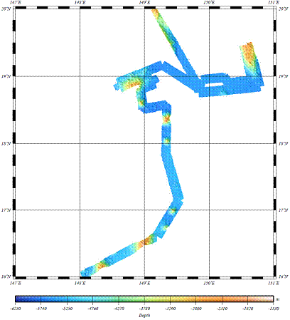
Figure 2. Bathymetry map in the survey area
2-3. Deep-sea scavenging fauna at 5400m in the Mariana Region, NW Pacific Ocean
The landers were deployed at 5575m (18°49.187N 149°50.583E; Video and 18°49.060N 149°51.021E; Stilles). The video lander was pre-programmed to record 1 minute of footage every five minutes and did so for the required 10 hours on the sea floor. The still lander took 1 image every one-minute (totalling 1540 images). The temperature and pressure were recorded every 30 seconds throughout (mean=1.5℃). The scavenging community observed comprises primarily macrourid fishes (Coryphaenoides yaquinae), although larger cusk eels and the occasional natantian decapod were also observed. The baited funnel traps attached to the video lander also collected approximately 500 individual amphipods for part of an ongoing population genetics project.
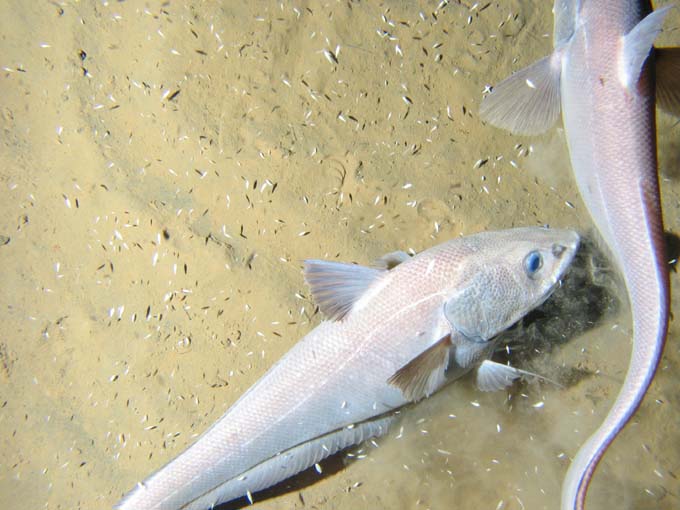
Photo 2. The deep-sea macrourid Coryphaenoides yaquinae at 5574m in the Marianas region.
3. Summary and Future Studies
We successfully recovered 2 OBEMs at 2 sites. The instruments measure geomagnetic and/or electric fields, and these data will contribute to a comprehensive image of the electrical conductivity structure for the Mariana island-arc system extending from the Pacific Ocean to the West Mariana Ridge (remnant arc) through the Marina Trough. Further, the surface geophysical survey data will be used for the topographic correction of electromagnetic data and provide additional information for an interpretation of electrical conductivity structure. These results will provide a breakthrough for understanding mantle dynamics related to plate subduction. Moreover, two free-fall landers were successfully deployed and recovered. The scavenging community observed comprises primarily macrourid fishes (Coryphaenoides yaquinae) although larger cusk eels and the occasional natantian decapod were also observed.
Acknowledgement
We gratefully recognize the efforts of the officers and crew (Hitoshi Tanaka, captain) of the R/V Kairei during the cruise. We thank all the support staffs in JAMSTEC. This research was supported by Japan Society for the Promotion of Science (Grant-In-Aid for Scientific Research (B)(1)(No. 15340149), Japan-US Integrated Action Program, and “The 21st Century COE Program of Origin and Evolution of Planetary Systems”), “Stagnant Slab Project (No. 17037003)” in Ministry of Education, Culture, Sports, Science, and Technology, Flinders University, the U.S. National Science Foundation MARGINS program, Nippon Foundation, Japan, and NERC, UK.