|
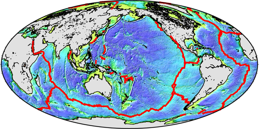
Mid-ocean ridge process and evolution of oceanic lithosphere
My main research target is seafloor spreading process at mid-ocean ridges and back arc spreading systems, where two plates are separated each other and new oceanic crust is accreted. Key question is "What is the main parameter controling the variety of oceanic crust/lithosphere structure?". I focus on the relationship between plate separation rate and melt supply. Recent research targets are melt-poor spreading system where large detachment fault dominates and excess-melt system where hotspot interacts the mid-ocean ridge process.
Main fiels are Indian Ridges and backarc areas of the Phillippine Sea. |
|
 |
|
|
|
 |
|
|
|
|
| |
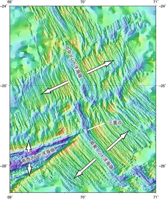
It is known that excess-melt ridge system where the melt supply is anomalously high compared to the spreading rate creates anomalous thicker oceanic crust. This phenomena can be clearly seen at mid-ocean ridges near hotspots and is named "hotspot ridge interaction". WE explored the Rodrigues Segment of the Central Indian Ridge where mantle plume originated from the Reunion hotspot interacts the ridge volcanism. We discovered a very contact point of two types of magmatism, one from mid-ocean ridge process and another from mantle plume, and also discovered a vast lava flow covering the axial valley floor. |
|
|
|
|
|
|
|
| |
In 2016, we visited this site again and extended the study area to the north in order to understand the ridge process. The area is also characterized by the existence of long-offset transform faults, and we started to investigate the detailed morphology and subseafloor structure of these transform faults. The contribution of seawater infiltration along oceanic transform faults and fracture zones is not negligible in global water flux, however, the degree and spatial extent of serpentinization around the faults system remain poorly constrained. Surface and deep-tow magnetic surveys were done across the Marie Celeste OTF and Argo OTF. Deep-tow magnetometer recorded larger amplitude, short wavelength variation across OTFs, where the surface data shows long-wavelength positive anomaly. The detailed analysis of magnetic data combined with gravity anomalies and distribution of minor faults will help the understanding of OTF tectonics and the horizontal extent of serpentinization using increase of ferromagnetic minerals and density decrease. |
|
 |
|
|
|
|
|
| |
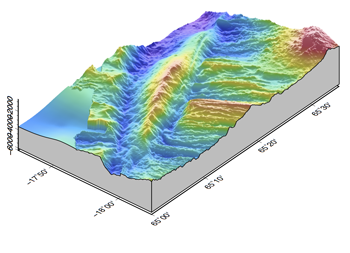
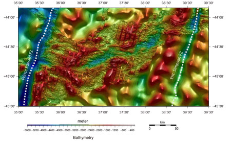
During the survey of the ultraslow spreading (1.5cm/year) Knipovich Ridge in the Arctic Ocean, we collected a detailed seafloor image along the ridge axis by using a deep-tow side scan sonar. We combined the compiled bathymetry, gravity, and sonar images and estimated the crust thickness variations and the distribution of volcanic activities. The volcanism along the ridge is sparse and localized, however a few magmatic centers are long-lived and forms the large volcanic constructions.
More details
|
|
 |
|
|
|
|
|
| |
The Southwest Indian Ridge is another ultraslow spreaidng system . I participated the French cruise in 2003 and was in charge of gravity data processing. The mappig survey covered not only the ridge axis but also off-axis areas up to 26 Ma, revealing that melt-poor, tectonic dominant, probably mantle exposed seafloor extends nearly one half of the surveyed area. |
|
 |
|
|
|
|
|
| |
The geophysical mapping (bathymetry, magnetics, and gravity) of the Australia-Antarctic Discordance, a part of the Southeast Indian Ridge, was done during the Hakuho-maru KH01-3 cruise in February 2002. We found a rugged, chaotic, unusual morphology indicating the amagmatic extension and the mantle exposure. The similar amagmatic features are mainly reported at the slow spreading systems, though the AAD is a intermediate spreading system.
More details (sorry, now only in Japanese)
|
|
 |
|
|
|
|
|
| |
Recent detailed mapping of the Parece Vela Basin, an inactive backarc basin behind the proto Mariana arc, shows that the anomalous morphological features indicating amagmatic dominant spreading extends over a largest scale in the world. The mantle rocks are recovered in the same area, showing the mantle exposure on the seafloor. The survey and study project is now going on.
More details (sorry, now only in Japanese)
Cruise Home Page (under construction)
|
|
 |
|
|
|
|
|
|
|
|
| |
Seafloor hydrothermal systems and its tectonic background
There are many marginal basins, small, semi-closed seas, in the northwestern Pacific. My target is the reconstruction of backarc basins in the Philippine Sea and the surrounding areas. |
|
|
|
|
|
|
|
|
|
|
|
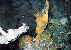
A few geological features indicating exposure of mantle material under melt-starved environment has been know around the Indian Ridge triple junction. A hydrothermal field "Kairei" located north of the junction is known to blow out the hydrogen-rich fluids. The hydrogen-rich hydrothermal vents are considered to be the result of interaction between seawater and mantle rocks, but the site is located on the basaltic rocks. It is an important site to investigate the variety of hydrothermalism and the circulation path of the field. The area is also an interesting site to understand the spatial and temporal variation of magmatism and tectonism, for many mantle exposures are scattered in the area. In 2006, we conducted the submersible-attached magnetometer survey on an oceanic core complex in the area and revealed the detail magnetic structure. In 2010, we did the integrated survey using AUV r2D4, CTD-tow yo, deep-tow magnetometer and rock dredges to understand the extent and characteristics of the hydrothermal plume and the geological and tectonic background of the hydrothermal field.
|
|
|
|
|
|
|
|
|
|
|
|
|
|
|
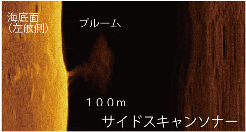
We can observe active hydrothermal activities associated with arc or backarc volcanoes along the Okinawa Trough. Recent surveys, especially using dee-sea platforms, revealed many new hydrothermal vents and IODP and other seafloor drilling projects were conducted. We carried out the high-resolution mapping in Irabu Knoll and Tarama Knoll using AUV URASHIMA in 2014. Our magnetic survey can reveal the demagnetization by hydrothermal circulation in Irabu Knoll. We also detected water column anomaly in multibeam echo sounder data and identified an unknown hydrothermal vent on the foot of the Tarama Knoll. The Irabu Knoll is hosted by backarc basaltic magamatism, on the other hand the Tarama Knoll is hosted by arc rhyolitic magmatism. In 2017, we plan to investigate the Yonaguni IV knoll, the westernmost hydrothermal vent in the Okinawa Trough by R/V Shinsei-Maru.
|
|
 |
|
|
|
|
|
|
|
|
|
Reconstruction of marginal basins inthe Philippine Sea
There are many marginal basins, small, semi-closed seas, in the northwestern Pacific. My target is the reconstruction of backarc basins in the Philippine Sea and the surrounding areas.
|
|
|
|
|
|
|
|
|
 |
|
The Shikoku and the Parece Vela Basins are the backarc basins which were formed between 27Ma and 15(12) Ma. We proposed a detailed history of basin formation, including the spreading direction change from E-W to NE-SW, change of spreading rate, and multiple ridge jumps.
|
|
|
|
|
|
|
|
|
|
The West Philippine Basin is the largest and oldest inactive basin in the Philippine Sea Plate. We conducted four research cruises from 1998 to 2000 in the area and succeeded the full cover geophysical mapping along the main part of the Central Basin Spreading Center, the remnant spreading axis of the basin. The survey result shows a large morphological and structural difference between the eastern "slow spreading" features and the western "fast-spreading" features. We consider that the difference is caused by the mantle temperature and/or geochemical heterogeneity due to a small-scale mantle plume.
More details |
|
|
|
|
|
|
|
|
|
|
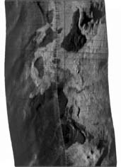
The Okinawa Trough is a backarc rifting zone behind the Ryukyu arc, where the continental crust is extended but the continuous oceanic crust formation has not yet occurred. We conducted the detailed seafloor imaging using our deep-tow side scan sonar in June, 2002. The analysis of volcanic and tectonic features using sonar images is now going on.
Cruise Home Page
(under construction)
|
|
|
|
|
|
|
|
|
|
High-resolution seafloor mapping techniques
Classic marine geophysical mapping from surface ship is a kind of remote sensing, where the survey object is located a couple of kilometers far, so the spatial resolution is much less than mapping on land. Recent development of deep-sea instruments (platforms) such as HOV, AUV and ROV has dramatically improved our investigation. We conduct high resolution bathymetry and geological mapping (1m order) and high quality magnetic survey (10m order) in deep sea and develop the data processing and analysis methods. |
|
|
|
|
|
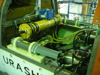
AUV-based magnetometer
We develop a small fluxgate magnetometer system for HOV and AUV surveys. Using the magnetometer, we obtain two dimensional, high-resolution magnetic anomaly maps and work for the hydrothermal alteration of oceanic crust, variation of paleo geomagnetic field intensities etc.
|
|
|
|
|
|
|
|
|
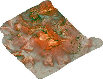
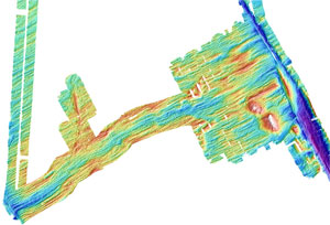
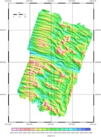
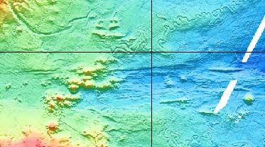
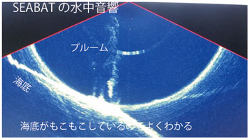
Example of AUV mapping. Red relief map of the Tarama Knoll, the Okinawa Trough. The water column analysis can detect the bubbles from new hydrothermal vent. |
|
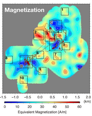
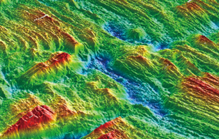
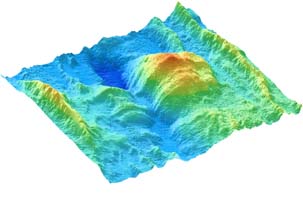
The seafloor magnetization map obtained by AUV-based mangnetic anomaly survey. The result clearly show the demagnetization by hydrothermal alteration (blue color). We try to detect unknown hydrothermal vent sites from magnetic surveys.
|
|
|
|
|
|
|
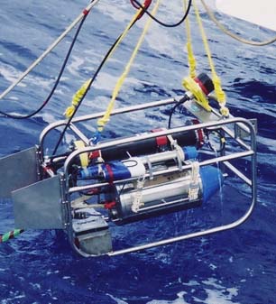
ORI group has developed a deep-tow magnetometer system. We utilized the system in order to detect a high resolution magnetic anomaly variation on the seafloor. |
|
|
|
|