 |
|
||||
1) Both multichannel seismic (MCS) reflection data and swath-bathymetric data revealed a buried circular seamount subducting beneath the Nankai accretionary prism off Shikoku Island, southwest Japan. The subducting seamount is responsible for deformation of the accretionary wedge, resulting in a compressed uplifted sediment knoll and many steep escarpments. We proposed a tectonic model for subduction of the seamount. |
||||
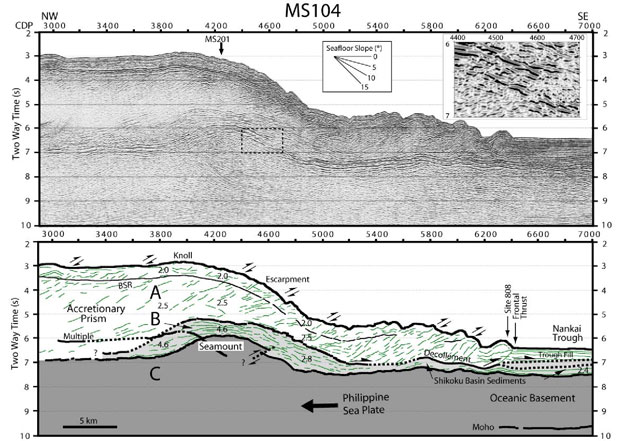
Time-migrated seismic profile (upper section) of line MS104 off Shikoku Island, and its interpretation (lower section). Vertical exaggeration about 3:1 at the seafloor. Numbers within each seismic unit in the interpretation indicate P-wave interval velocity which is calculated from stacking velocity. A zoomed-up seismic image showing a conspicuous discontinuity of the topmost reflector of the subducting seamount, is represented on the upper right corner of the seismic profile. |
||||
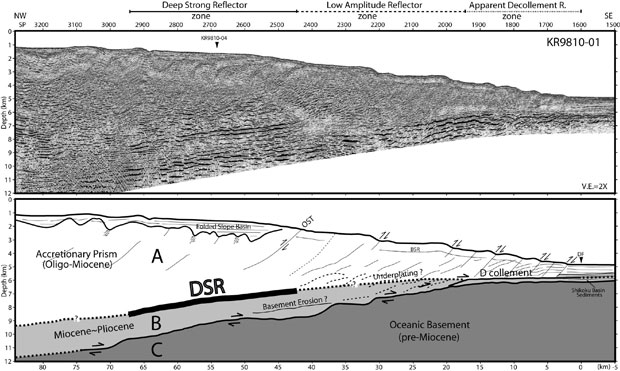
| 2) An anomalous reflection of deep strong reflector (DSR) in the Nankai Trough convergent margin off Shikoku Island shows relatively smooth, continuous reflection character in dip directions, and is almost parallel to the top of subducting oceanic basement, suggesting that the DSR is related to the ongoing subduction process. The DSR is interpreted as a roof thrust fault plane related to the underplating process which may be caused by landward increased interplate coupling in the interseismic locked zone. The DSR distribution with southwest trend shows that a seaward shallow area including the DSR zone lies mostly outside the rupture area of the 1946 Nankai earthquake, even though most of the DSR is within the locked seismogenic zone, leading us to speculate that the DSR plays an important role in the release of shear stress energy stored in the shallow area. | ||||
|
||||
| 3) Seismic reflection profiles reveal steeply landward-dipping splay faults in the rupture area of the magnitude (M) 8.1 Tonankai earthquake in the Nankai subduction zone. These splay faults branch upward from the plate-boundary interface (that is, the subduction zone) at ~10 kilometers depth and ~50-55 kilometers landward of the trough axis, breaking through the upper crustal plate. Slip on the active splay fault may provide an important mechanism to accommodate the elastic strain due to relative plate motion. | ||||
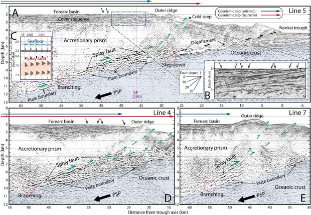 Poststack depth migrated MCS profiles showing the splay faults. Subducting oceanic crust is shaded by light blue color. Seaward distribution of the 1944 Tonankai coseismic slips estimated from tsunami (red line) and seismic (blue line) inversions are projected in the profiles. Locations of both the splay fault's initial branching and the déollement stepdown to the top of the oceanic basement are marked in red dotted circles. Green and black arrows show motions of the splay fault slip and the décollement or normal fault, respectively. Vertical exaggeration is 2X. (A) MCS profile on line 5. The Philippine Sea Plate (PSP) subducting beneath the upper plate produces a huge accretionary prism. Location of the cold seep is marked in asterisk. Note active normal faults (inset B) cutting the well-stratified, landward tilting cover sequence and reverse polarity reflection (inset C) of the splay fault at ~7 km depth around shot point (SP) 2365. (D) The active normal faults are also observed on line 4. (E) The splay fault is also identified on line 7, which is separated from line 4 by ~80 km distance. |
||||
| 4) Recent seismic reflection and refraction data reveal a trough-parallel subducted oceanic ridge that is attached to the descending Philippine Sea Plate beneath the accretionary wedge of the overriding Eurasian Plate in the eastern Nankai Trough subduction zone consisting of the Tonankai and Tokai segments. The seismic survey data confirms the existence of subducted paleo-Zenisu ridge that was suggested by just magnetic data, and as a result, expands its distribution to the west. The newly constrained subducted ridge that spans the two segments is estimated to be a maximum of ~2.5 km high, ~20-30 km wide, and ~200 km long. Spatial mapping of the ridge shows that it is located roughly at the seaward edge of the coseismic rupture zone of the 1944 Tonankai earthquake (M = 8.1). This ridge appears to be in close contact with the seaward end of the rigid backstop in the Tonankai segment. Both the spatial correlation and the ridge-backstop collision geometry suggest that the subducted ridge might be strongly mechanically coupled and may thus play a significant role as a seaward barrier inhibiting the 1944 earthquake rupture from propagating farther seaward. | ||||
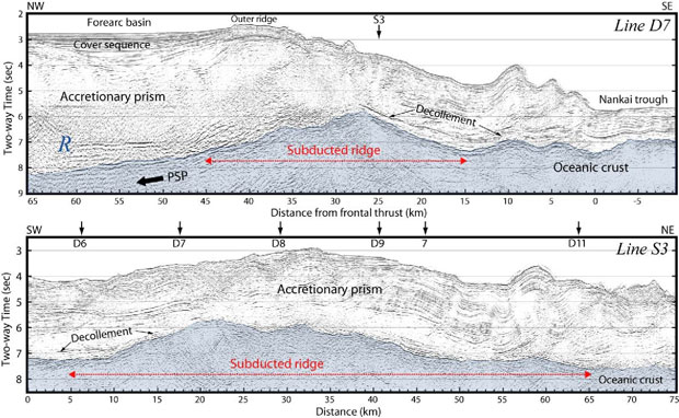 Time-migrated MCS profiles of dip line D7 and strike line S3 showing the subducted ridge in the Tonankai segment. Subducting oceanic crust is shaded in light blue. Vertical exaggeration is about 4:1 at the seafloor. |
||||
| 5) In order to figure out seismic structure and stratigraphy of the Nankai accretionary wedge off Cape Muroto of Shikoku Island, southwest Japan, we have conducted three-dimensional (3-D) multichannel seismic (MCS) reflection survey using R/V Ewing in 1999. We acquired the MCS data on 81 separate lines with 100 m line spacing, each 80 km long, producing 8 X 80 km 3-D seismic volume. To obtain the 3-D prestack depth migration images, we constructed and updated a 3-D interval velocity model using the CDP bin gathers for which preconditioning processings including amplitude recovery, deconvolution, and multiple suppression were applied. | ||||
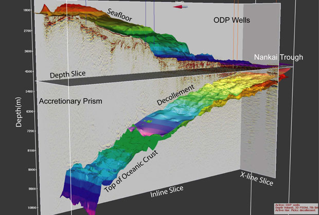
3-D prestack depth migration images (inline slice, crossline slice, and depth slice) of the Nankai accretionary wedge off Shikoku Island. Miocene to Pliocene Shikoku Basin sediments underthrusts the overlying accretionary prism along a decollement as the Philippine Sea Plate subducts beneath the Eurasian Plate. The oceanic crust of the subducting Philippine Sea Plate (PSP) is traceable over the entire inlines. Several imbricate thrust faults are observed in the overlying accretionary wedge. The decollement steps down on the top of subducting oceanic crust around ~30 km landward from the deformation front. |
||||